


About Dedoplistskaro
Dedoplistskaro is an administrative center of the eponymous district in eastern Georgia, located in Shiraki valley, with a populace of about eight thousand people. Declared as a city in 1963.
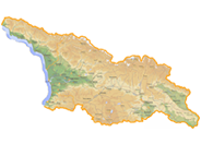
Municipality of Dedoplistskaro has an area 2.532 square meters, over 2, 22 percent of Kakheti. It is placed in the bottom land of Alazani and Iori rivers, on an elevated plateau. The lowest point is 90 m above sea level at Mingechaur reservoir, and the highest – at 1001 meters on Mount Nikorastsihe, located southern of the city.
In the south part of the municipality is a Vashlovani reserve covering an area of more than 10 000 ha. On the territory of reserve are several rivers dry up periodically. The area surrounded by chain of mountains. And to the west of the reserve in Eldary lowland is a lowest in eastern Georgia point at 90-150 m.
The central and northern parts of the region are mainly engaged in arable lands, vineyards, orchards and other.
Region is bordered to the east and south with Azerbaijan and to the west and north with Sighnagi district.
Since ancient times, the city was part of the historical province Kambechovani. Originally it was closely associated with the history of the state and is an integral part of Kakhetian and Heretian reigns.
Due to its location and natural conditions in this area since ancient times life was in full swing, as evidenced by numerous historical monuments, archaeological finds, cobbled streets and sophisticated irrigation system.
In the 17-18 centuries in Kambechovani lived almost 70-80 thousand people, and in the main city Khornabudji even about 10-15 thousand.
In the 12th century, during the reign of Tamar, the fortress became fiercer and even participated in international relations.
In Kiziki to this day there is a legend that the queen with her husband David Soslan visited Kambechovani and lived two weeks in Khornabudji. At the top of the mountain was flowing purest source. Queen drunken water from a golden cup, ordered to bring water to the castle, but without damaging the source.
In the same year the water was delivered to the fortress Khornabudji by clay pipes, and the area is called the king’s wells, which means Dedoplis Tskaro, which later became the city. On the mountain is still flowing the spring called the spring of Tamar.
District is rich of cultural heritage and historical monuments.
Khornabudji fortress of 3-4th centuries, built on a rock and contains the remains of various structures, including reservoir and the church. Driving here in 1858, Alexander Dumas described Khornabudji and Mount Elia.
Located in the eastern part of lori hill district Dedoplistskaro mainly represented by hills and low mountains. It should be noted Taribana, large and small Shiraky valley and mountain Elia, which is shaped like a recumbent figure of the deceased woman.
District combines the city and 14 villages. Mirzaani is home to the famous Georgian self-taught artist – Niko Pirosmani, which is represented by his house-museum and is held annually in the fall the festival dedicated to the works of the great masters.

